

Using the CLI
The localize command was introduced in SDK 0.14.0. It loads a pre-built point cloud map,
streams lidar data from a sensor or recording, and continuously estimates the sensor’s pose
relative to the map.
Basic Usage
ouster-cli source {SOURCE} localize {MAP} viz
Replace {SOURCE} with a sensor hostname/IP, or a path to a PCAP or OSF file.
The {MAP} argument is a PLY (or PCD) file produced by a prior SLAM run (see
Save Command).
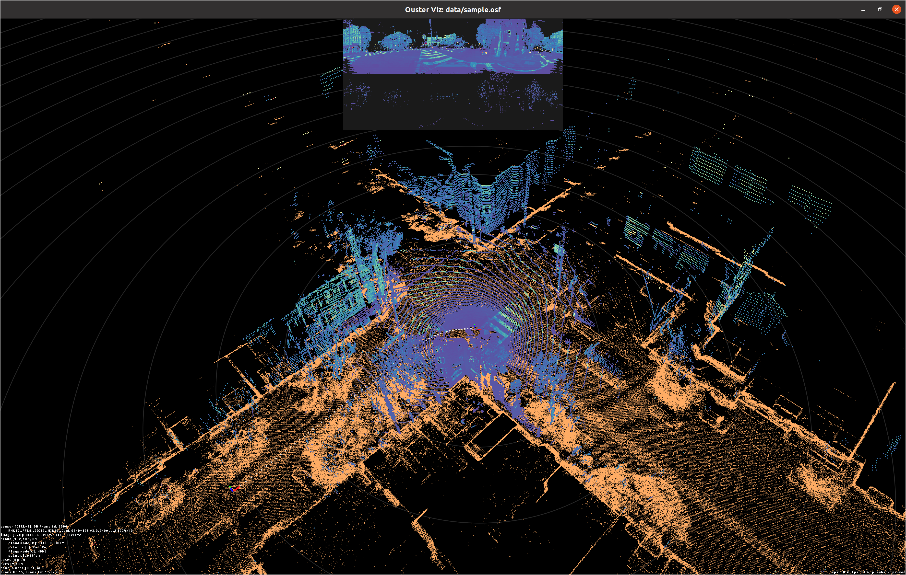
When you append viz after the map path, the Ouster Visualizer loads the reference map in the
background (flattened by default), streams lidar from the source, and updates the sensor pose
relative to the map origin:
Note
Map files must be point clouds in PLY or PCD format.
You can also chain save output.osf to record the localized stream:
ouster-cli source {SOURCE} localize {MAP} save {OUTPUT_OSF}
localize Command Reference
To see all available options:
ouster-cli source {SOURCE} localize --help
Flag |
Default |
Description |
|---|---|---|
|
(required) |
Path to the point cloud map file (PLY or PCD). |
|
|
Lower limit of range measurements in meters. Points closer than this are excluded. |
|
|
Upper limit of range measurements in meters. Points beyond this are excluded. |
|
auto |
Map voxel size in meters. When omitted (or |
|
|
Deskewing strategy: |
Setting the Initial Pose
The above commands work well when the input source begins from the same place as the origin of the map, however, in many situations this isn’t the case. In the case of wanting to start from a different starting point than the map origin, the user could do that using the following:
ouster-cli source --initial-pose {PX},{PY},{PZ},{R},{P},{Y} {SOURCE} localize {MAP} viz
This would set the initial pose of the input source with respect to the map origin,
where PX,PY,PZ represent the position and R,P,Y represent orientation in Euler angles (roll, pitch, yaw) specified in degrees.
When not specified, the initial pose defaults to the identity matrix (the map origin).
For the Python API, see Setting the Initial Pose in Using the API.
Tuning Range and Voxel Size
Adjusting range gates removes irrelevant points (e.g., the robot’s own frame at close range, or noisy returns at long range):
ouster-cli source {SOURCE} localize {MAP} --min-range 0.5 --max-range 80.0 viz
Setting the voxel size explicitly gives you control over the map resolution used for matching:
ouster-cli source {SOURCE} localize {MAP} --voxel-size 1.0 viz
Selecting the Deskew Method
On sensors running FW >= 3.2, auto uses IMU-based deskewing for more accurate motion
compensation. You can override this:
ouster-cli source {SOURCE} localize {MAP} --deskew-method constant_velocity viz
Reference map appearance
The localization viz command accepts options prefixed with --global-map- to control how
the static map is drawn. For example, show the map in 3D without flattening:
ouster-cli source {SOURCE} localize {MAP} viz --global-map-flatten False
You can combine several --global-map-* flags—for example Z clipping, downsampling, and point
size:
ouster-cli source {SOURCE} localize {MAP} viz \
    --global-map-flatten True \
    --global-map-min-z -1.0 \
    --global-map-max-z 5.0 \
    --global-map-voxel-size 0.5 \
    --global-map-point-size 2.0
The full list of --global-map-* flags:
Flag |
Default |
Description |
|---|---|---|
|
(from localize) |
Override the map file displayed in the visualizer. This does not affect the map used for registration — only the visual display. |
|
|
When |
|
(none) |
Filter out map points below this Z value (meters). |
|
(none) |
Filter out map points above this Z value (meters). |
|
(none) |
Downsample the displayed map using this voxel size (meters). Reduces visual clutter and improves rendering performance for large maps. |
|
|
Point size for the rendered map cloud. |
To see every flag directly, run ouster-cli source <SOURCE_URL> localize map.ply viz --help.